
*This post contains affiliate links, if you click a link I make a small commission and you help support the blog
The vast natural spaces in Canada are plentiful and stunning. From the open spaces in the prairies to the seaside towns in the Maritimes, the hiking is unforgettable.
With so many options how do you decide which to do first? Why not take a road trip across Canada and try them all? This week’s round-up from fellow bloggers gives you the top day hikes across the country to help you plan your escape into some of the best natural spaces in the world.
Balancing Rock Trail
By: Nicole at Wandering with a Dromomaniac (that’s me!)
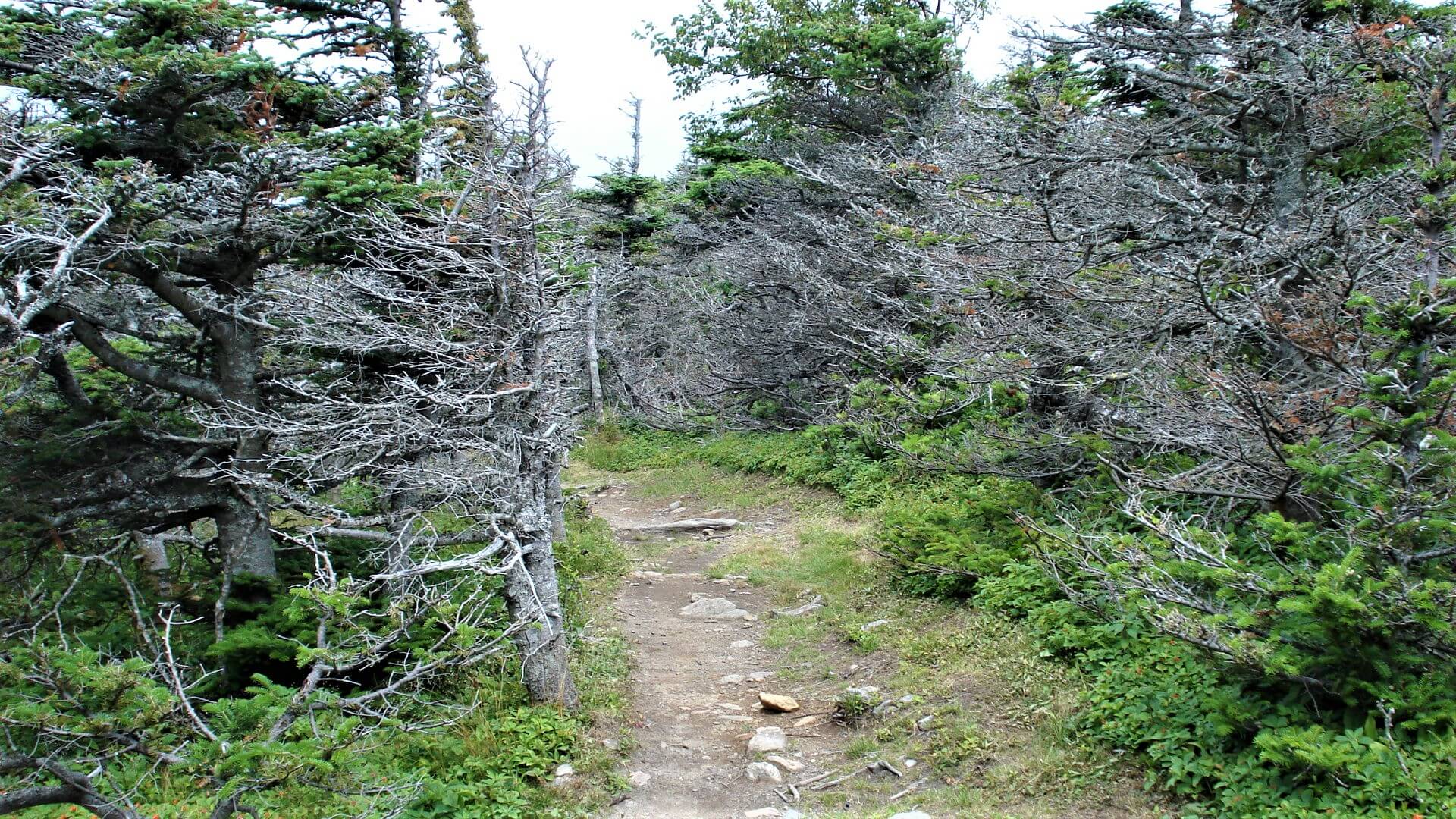
On a small island off of Nova Scotia is a trail leading to the sea. But it doesn’t just lead to the sea, it leads to cliffs of Basalt rock that have had millions of years to form and sculpt into what is now known as Balancing Rock.
A major attraction to tourists and locals alike this 1.7 km hike takes you through evergreen forests with a mixture of rocky and sandy trail, down 235 steps to a large platform jutting out into St. Mary’s Bay. On either side of the platform rock face juts up around you as fishing boats slowly troll by.
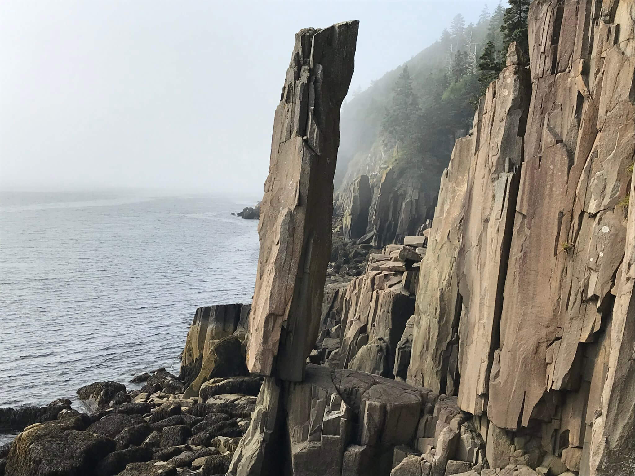
Not only is it a wonder to marvel at, it has an interesting bit of history to go along with it. For a long time, this was not a tourist destination. It was a place that fisherman saw while out on their boats. There is even a story of a group of fisherman tying a rope around the rock and trying to pull it over, with no success.
It’s an easy hike, but a great thing to do during your visit to Nova Scotia. And you never know, you might even see a humpback whale breach off the shore.
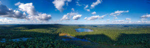
McCrae Lake Conservation Trail
By: Mikaela at Voyageur Tripper
McCrae Lake Conservation Trail is a moderately challenging day hike less than two hours north of Toronto. Although two hours is a little far to drive for a day hike, McCrae Lake is such a beautiful lake that it makes the trip well worth the effort. The scenery is beautiful, there are some stunning lookouts, you’ll have the opportunity to cook lunch over a fire or go for a refreshing swim. All just a short drive from the big city!
The trail is an “out and back” trail and covers 7 km each way, which requires 5-6 hours to complete (however, I’d budget some additional time because the trail can be deceivingly tiring at times).

There are some sections where the trail is narrow, the soft soil covered in orange pine needles, and winds through sugar maple forest. Other sections of the trail crossed exposed granite rock characteristic of the Canadian Shield; here the Eastern White Pines soar above and bend under the strong force of the prevailing Georgian Bay winds. Although there aren’t any long and steep climbs, parts of the trail are very rocky and can be difficult to navigate. There are a few excellent viewpoints along the way, including Eagle’s Nest which offers the first view of McCrae Lake.
At the end of the trail, there is a pathway to get down to the water. Here there is a campsite that can be used for backcountry camping or for relaxing after completing the first half of the hike. When I last hiked McCrae Lake, we built a fire (there is a fire pit at the campsite) and fried wraps. Afterwards we went for a swim in the sparkling blue waters of McCrae Lake.
Before setting out for the hike there are a few things to keep in mind. Due to the rugged nature of the Canadian Shield, hiking shoes are strongly recommended (I wore running shoes and rolled my ankle the last time I was there). I’d even recommend bringing trekking poles if you have bad knees or want a little extra support for some rocky sections of the trail. In addition, as some of the trail is exposed, bring sunscreen and more water than you think you’ll need – it can get really hot!
Joffre Lakes Hike
By: Luke and Roxy at The Coastal Campaign
The Joffre Lakes Hike is one of the best hikes in British Columbia. The trail takes you past three different glacial lakes, all with varying shades of blue and turquoise, which are absolutely spectacular. The hike can be found a short drive from Pemberton and it takes about 2.5 hours to drive here from downtown Vancouver.
The hike is a 10 kilometre out and back again trail with 370 metres of elevation gain. This should take you around 4 hours to complete if you go all the way to the Upper Joffre lake. This is one of the most popular hikes on the west coast which means it is usually very busy, especially on weekends. Try and hike during the week if possible and if not, turn up early in the morning to find parking and to beat the crowds.
The first lake is just a few minutes’ walk from the car park along a flat path. This lake is an lighter shade of blue/green and while beautiful is the least spectacular of the three lakes. Between the Lower Joffre Lake and the Middle Joffre Lake is where the majority of the length and elevation of this hike is found. The trail is pleasant though as you wind through the trees and into the valley with mountains towering above you.
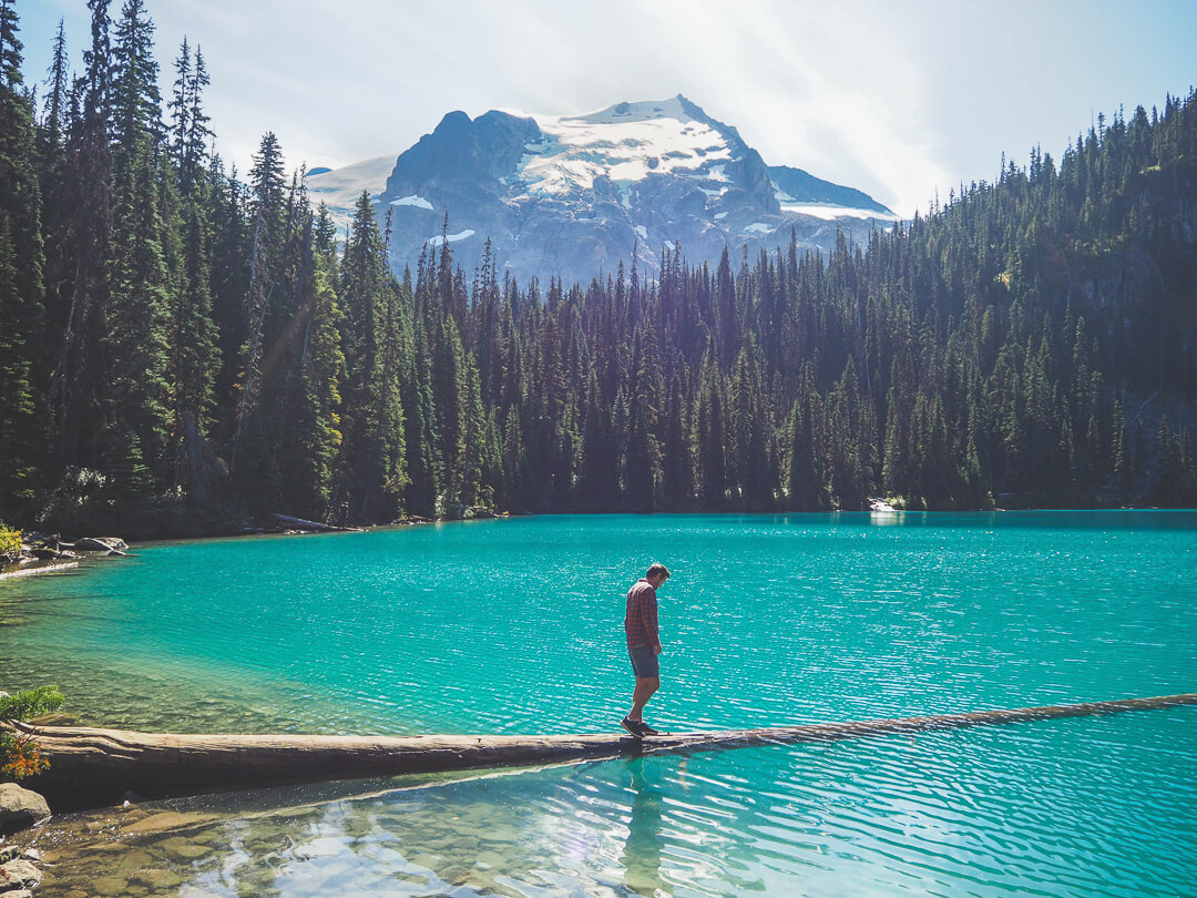
The middle lake is the most beautiful due to the bright blue colour of the lake. There are lots of places to sit and enjoy some lunch right by the edge of the water and you can enjoy the views of the surrounding mountains and the glacier that sits above the upper lake as well. If you are feeling really brave you can swim here, although the water is exceptionally chilly.
The final section of the hike takes you to the Upper Joffre Lake which is a slightly lighter shade of milky blue. You get more incredible scenery here as you see the glacier from much closer. You can also camp at the Upper Joffre Lake although you will need to book months in advance to get a spot.
Once you have had your fill of blue lakes, mountains and glaciers you can make your way back down to the car park along the same trail. This is a spectacular trail and one of my favourite hikes near Vancouver.
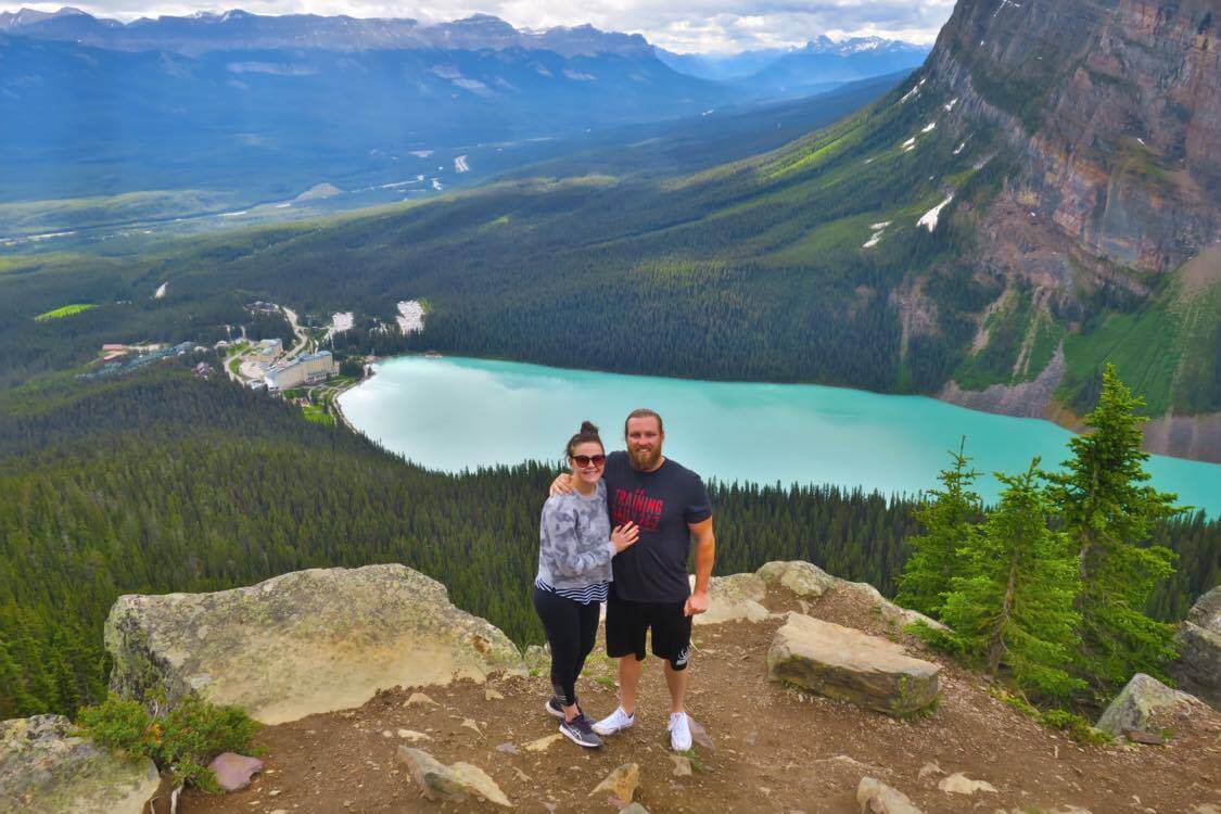
Beehive Hike at Lake Louise
By: Chelsea at BRB Busy Living Life
The Beehive Hike at Lake Louise is the ultimate Canadian hike. This hike is extremely tough but so worth it.
Although tourists can view Lake Louise from ground level, viewing this idyllic lake from above is a view like no other.
After hiking up the hill for one – two hours (depending on fitness level) you are met with a Birdseye view of Lake Louise that is stunning and one to remember.
To access this trek, hikers can park in the Lake Louise parking lot and simply walk to the beginning of the trail. My one major tip about doing this hike is to arrive early; around 6:00 – 7:00am. At approximately 9:00am the parking lot, the ground viewing points and the Beehive Hike trial get extremely full. As this hike is a relatively short up and back trail, you can be on your way back down before the hoards of people arrive.
I would not advise doing this hike if you do not have at least a moderate – good level of fitness as the inclines are intense and a constant the entire way up to The Beehive.
On the way to the top, there are many amazing views to be taken in. Although the hike is gruelling and you no doubt just want to get to the top, be sure to take some time to admire the views along the way.
Nestled about half way from the bottom to the top of the Beehive Hike is the famous Lake Louise Tea House that should also be enjoyed. This famous pit stop cafe is found right next to a flowing stream, in which the water for the hot beverages is taken directly from. For people who may not be able to do the entire beehive hike, the tea house is an achievable distance for most.
When you reach the top of The Beehive Hike (while catching your breath) be sure to pat yourself on the back for completing such a tough hike! I can guarantee that as soon as you take in the beautiful scenery from above, pushing yourself through the extremely difficult hike will be worth it!
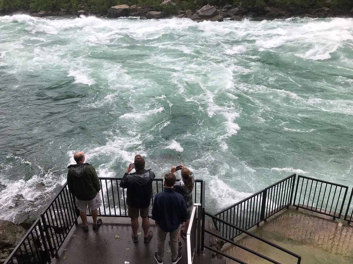
Niagara Glen Trails in Niagara Falls Canada
By: Christina at Travel2next
A 6.8-mile gorge carved over the years of erosion by Niagara Falls and the Niagara River, Niagara Gorge straddles the Canadian and USA border. Located across the U.S. state of New York and the Canadian province of Ontario, the gorge is a fantastic place to go for a day hike in Canada’s Niagara Falls region. You’ll soon see why hiking the Niagara Glen Trails is one of the spectacular things to do in Niagara Falls if you love the outdoors.
The easiest way to get down into the gorge is to hike down (or take the elevator) to the bottom and start with the White-Water Walk, where day-trippers and sightseers can get so close to the river you’ll be able to feel the power of the Class 6 white-water rapids. This part of the river boardwalk has a series of educational boards and jaw-dropping views of the 410-million-year-old layers of rock on this easy trail.
For a longer hike, head to the north of the White Water Walk and down the stairs at the Whirlpool to access the Cliffside Trail where you walk past towering limestone cliffs. The 4km of Niagara Glen hiking trails are ranked as moderate or difficult, and the trails are rugged and uneven, so make sure you wear good hiking shoes. There are eight trails and one boulder trail, and to hike all the trails would take the entire day.
At the end of the Cliffside Trail, it splits into the Cobblestone Trail the Terrace Trail, which is a stunning landscape of boulders and you’ll squeeze through cervices. The Terrance Trail joins up with the River Trail along the Niagara River.
Niagara Glen is a year-round destination but be careful in winter as the trails can get icy and slippery. The best season to hike is in fall as the autumn leaves are stunning.
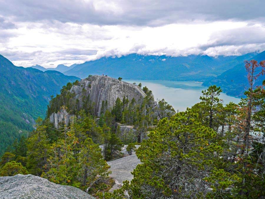
Stawamus Chief Mountain
By: Campbell and Alya at Stingy Nomads
Stawamus Chief Mountain, usually referred to as The Chief, is a massive granite rock outside the village Squamish close to Vancouver. The second largest monolith in the world, behind the Rock of Gibraltar, it has three peaks that you can hike to. Climbing this steep wall of granite is world renowned in rock climbing circles.
The Chief hike is a challenging trail and chains and ladders are needed in some parts to climb up the steep sections of the trail, scrambling up the gullies separating the three peaks. The steep trail reaches viewpoints with incredible vistas of the area surrounding Squamish, including Howe Sound and north to Garibaldi Provincial Park.
The whole trail is well marked with diamond-shaped trail blazes on trees. Hikers follow the main trail with turn-offs marked with signposts leading to the three peaks along the way. The Chief hike is an out and back trail, heading to a specific point on top of the rock before the trail backtracks to the starting point.
The complete trail takes anything from 3 to 6 hours to complete for people of varying fitness levels. To do a shorter hike you have the option of only hiking to the 1st or 2nd peaks which take roughly 2 to 3 hours to the top and back. Due to its proximity to Vancouver the hike can get very busy in summer. Since the smooth rock is slippery when wet, hiking here in rainy weather is not recommended. The hiking season for The Chief is from late March until the end of October.
To reach the Chief hike drive on Highway 99 for 55km from Vancouver about 5 km south of Squamish stop at the parking area at the Stawamus Chief Campground. The trailhead is at the east end of the campground. Daily return transport from Vancouver to Squamish is available with the Squamish Connector.
Concluding Thoughts
Canada has so much beauty to explore, but you don’t have to take it from me. From hiking on the Gentle Island of Prince Edward Island to Mount Benson on Vancouver Island and everything in between, no matter which province you visit you will never be short on impressive hikes.


Comments
I loved your article! Thanks for some great information!
Author
I’m so glad you found it helpful! Thank you!