
* This post contains affiliate links. This means if you click on a link and make a purchase you are helping to support this blog.
The United States has a surprising amount of amazing nature to explore and a huge number of day hikes, it can be hard to decide where to start.
From the National Parks to State Forests and National Monuments, we’ve got you covered. It is my hope that this round-up will guide you to your next hiking adventure in the US.
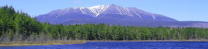
Mount Katahdin
By: Nicole from Wandering with a Dromomaniac (that’s me!)
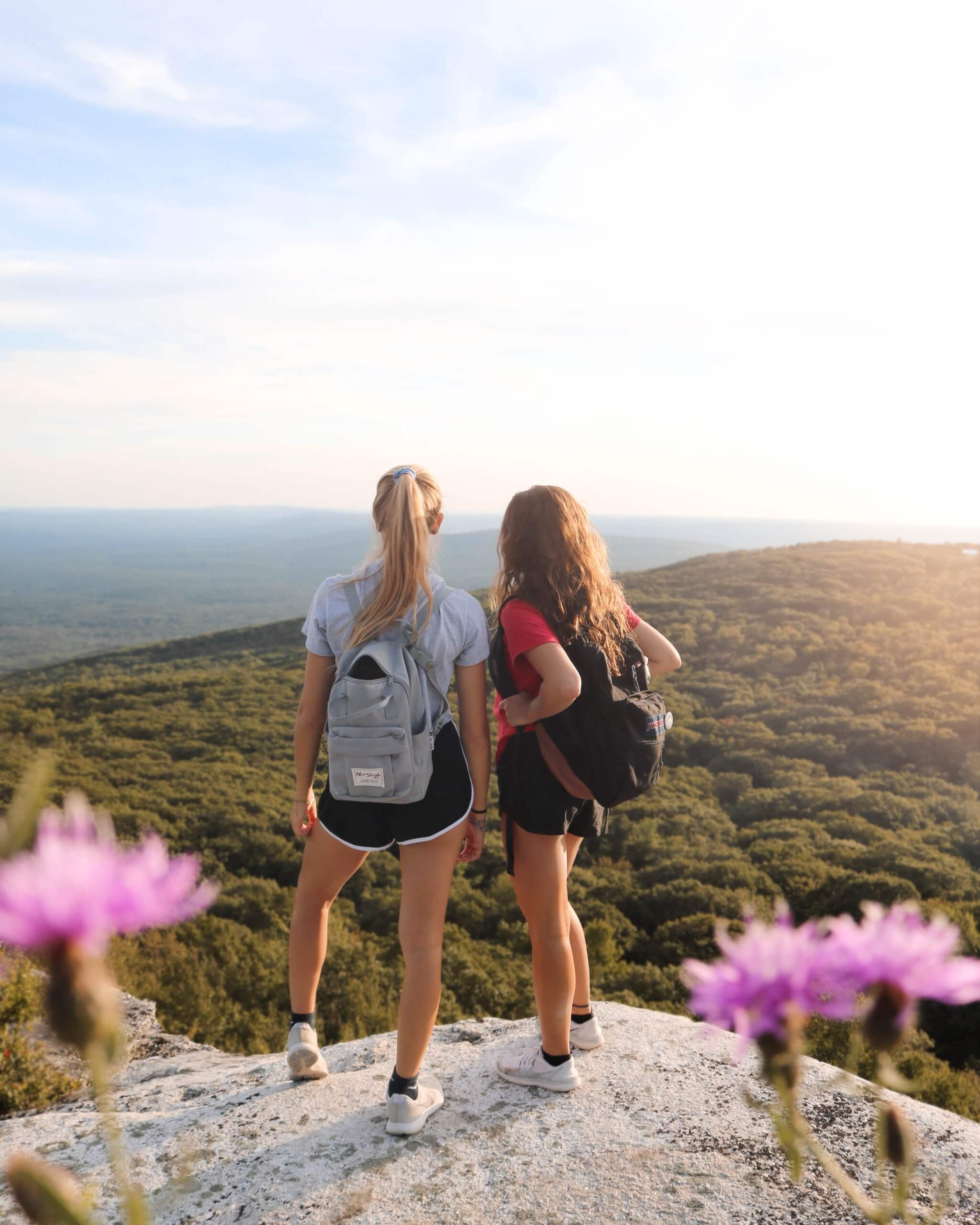
Mount Katahdin, in Baxter State Park, Maine is an absolute must hike. The official end of the Appalachian Trail this is a difficult hike that will take you all day. So, start early and bring plenty of water.
There are tons of options, however, when it comes to how to go about summiting this mountain. I recommend the Hunt Trail, as it starts at a campground where you can spend the night prior to your summit. The trail changes the higher you climb, with evergreen forests that slowly begin to shrink as the air becomes thinner. The terrain goes from hard pack rock trail to boulder fields and open plateau.
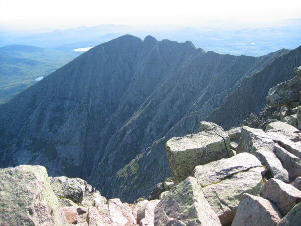
If you’re brave enough (which I was not) you can also walk out along the Knife’s Edge trail while enjoying the views from the summit. But be aware, the weather on the mountain is extremely unpredictable and it’s a tough challenge, so wear good hiking shoes and be aware of what to pack to summit Mount Katahdin.
I recommend starting the hike before the sun comes up so that you will have plenty of time to enjoy a lunch on the top before making the return hike. It will take 6-8 hours, depending on your hiking speed and fitness level. You may even have the opportunity to see the celebrations as AT thru-hikers finish their 2,000+ mile journey!
It may even inspire you to start your own journey along the AT.
Devil’s Lake Wisconsin
By: Paulina from Paulina on the Road
If you are a person who wants to burn calories and not be involved in a competitive sport but simultaneously admire nature, then hiking is the activity for you. It is the perfect journey where you climb up the slope and embrace the greens, the breath-taking view of different landscapes.
If you are looking for a unique trail to do, have a look at the East Buff Part of the Ice Age Trail, which lies in the bank of the Devil’s Lake, Wisconsin. Home to some of the most romantic cabins in Wisconsin, this trail is a must-do!
Situated in Baraboo, Wisconsin, USA, the best part about the trail is the stunning view from atop the cliffs of the Devil’s Lake and the adjoining landscape. For some people, it could be difficult to climb up the East Buff from North shore, but with the help of the Asphalt trail, people can climb up the rock steps and overlook the view.
If one doesn’t intend to give up on the trail, it could take as long as 4 hours to complete the hike. The journey to the East Buff starts from North Shore up-to-the Elephant Cave where you discover the first outlook, and from there on the path becomes rippled with the formation of quartzite rocks spread around.
This pathway is also surrounded by breath-taking views before it intersects the balanced Rock Trail to the South. One segment of this trail is connected to the Devil’s Doorway, where you get to witness the Devil’s Doorway Rock Formation.
As these trails are ideal during the summer and fall season, it is not recommended to hike in Winters as the trails are not maintained so it could be slippery and covered with ice, in addition to this the visitors need to be careful when hiking on rock ledges in Devil Doorway as many have died falling from this location.
Mount Whitney
By: Allison from She Dreams of Alpine
The Mt. Whitney hike could be considered the ultimate day hike in the United States, since the summit is the highest point in the lower 48 states at 14,505 feet. While the 20-mile out and back hike and 6,200 feet of elevation gain makes for an extremely long, tough day, the Mt. Whitney trail can definitely be done as a challenging but rewarding day hike.
The beginning of the Mt. Whitney hike takes you through the beauty of the John Muir Wilderness, where you’ll encounter lots of flora and fauna. You’ll have to get a very early start if you’re day hiking, but you will be rewarded with lovely sunrise views. After passing several alpine lakes, you’ll make your way above treeline, and start the seriously steep uphill slog of the 97 switchbacks to the top. Physically training for this hike a few weeks or months ahead of time will help make this section slightly less arduous. Although these switchbacks can feel never-ending when you’re trudging along them, the trail finally levels out as you approach the summit, and soon you’ll find yourself standing on what feels like the top of the world!
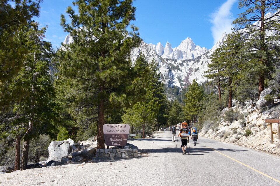
Located in the Sierra Nevada mountain range near Lone Pine, CA, Mt. Whitney is an extremely popular hike, and a permit is required. Permits for the main hiking season are released through a lottery system each year, so you have to apply early (the window runs from February to mid-March) if you want to have the chance to hike Mt. Whitney. Any unclaimed permits from the lottery are released in April, and during the hiking season you might be able to snag a permit through a last-minute cancellation. But if you have your heart set on hiking Mt. Whitney, it’s wise to plan ahead to give yourself the best chance of getting a permit.
Despite the physical rigors and the advanced planning it takes to complete the Mount Whitney hike, standing on the soaring summit and knowing you’re at the tallest point in the lower 48 states makes all the effort worth it!
Devil’s Garden Trail in Arches National Park
By: Jarrod at Ramble Around the World
One of the most beautiful parts of Arches National Park also houses the best hiking trail in the park, Devils Garden Trail. Set at the end of the park’s paved roads, the out-and-back hike can be completed in two different ways: the 10-mile primitive loop or the 7.2-mile regular hike.
Both routes are spectacular in their own right. The primitive loop takes you deeper inside the massive rock fins jutting out from the ground, giving you an up-close view of the 13,000-plus-foot La Sal Mountain Range that remains snow-capped much of the year. While the regular hike takes you out and back on the same path.
But both trails pass by seven named arches and take you hiking on knee-knocking narrow rock fins, sandy terrain and rocky structures. The most famous arch on the trail is by far Landscape Arch, a 306-feet long arch towering over the trail at just 11-feet thick at its most vulnerable point.
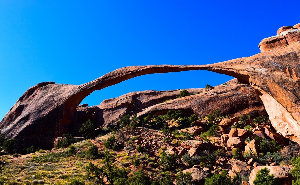
Landscape Arch is the most popular and it’s only 0.8 miles into the hike. The path there is partly paved and entirely packed down, so people of all walks can easily hike to hike. But after you see this arch is when the real hiking begins and where you can beat the massive crowds that flock to this trail.
Just after Landscape is a massive rock fin that’s both steep and narrow. Its slippery slope deters many hikers from taking it on. But you must hike it to see four more arches that are definitely worth the journey.
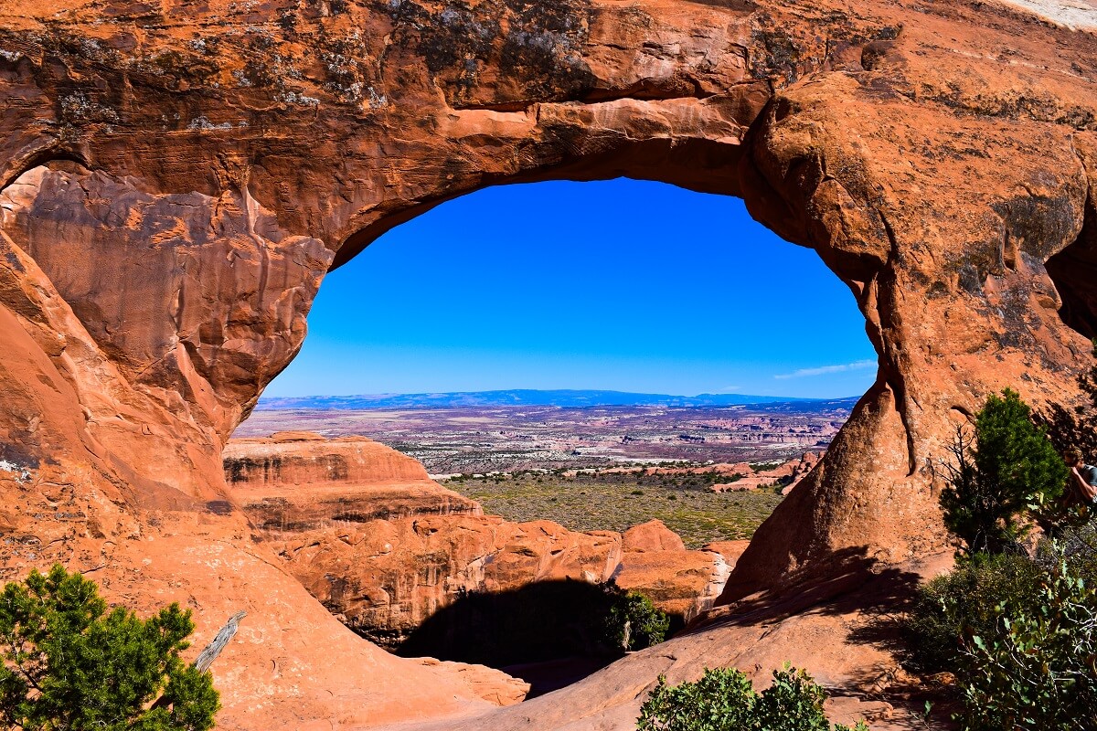
After navigating the massive rock fin you’ll feast your eyes on Navajo Arch, a cave-like structure that’s one-of-a-kind in the park, and Partition Arch. The latter holds one of the most spectacular views in the park because its juxtaposition frames the deep valley and towering mountains inside a deep red and brown arch. Seriously, it’s one of the best sights in the park.
Continue and you’ll catch a glimpse of Double-O Arch and Private Arch, each phenomenal in their own right. I stopped to take photos, have lunch and wound up hiking a little over 11.5 miles on the trail, so it took me a solid six hours to complete the hike. However, if you opt for the 7.2-mile trail and don’t stop as many times as I did, it may only take you three hours.
Angels Landing
By: Anna from My Travel Scrapbook
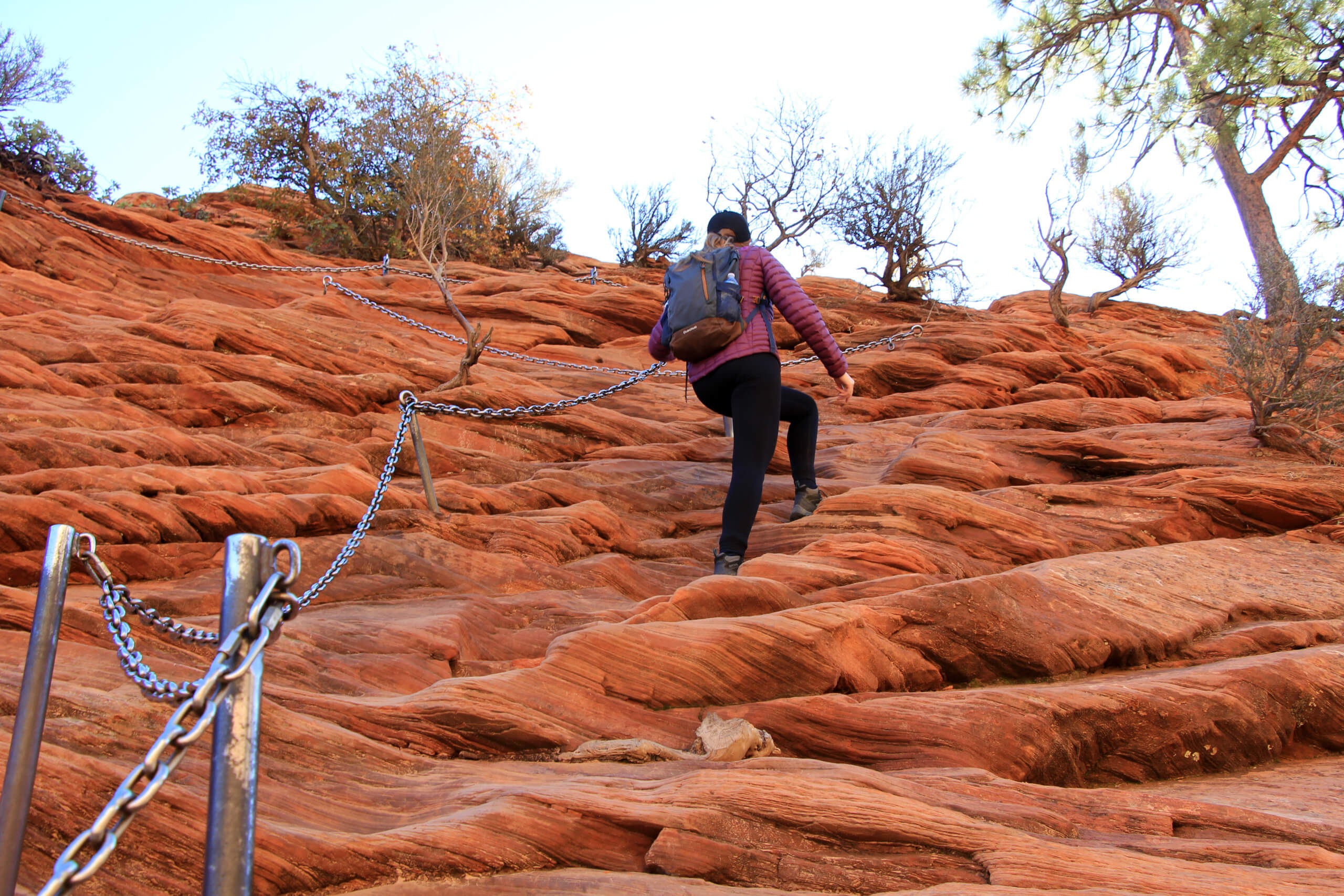
One of the best, most famous and most dangerous hikes in the USA is Angel’s Landing trail in Zion National park in Utah.
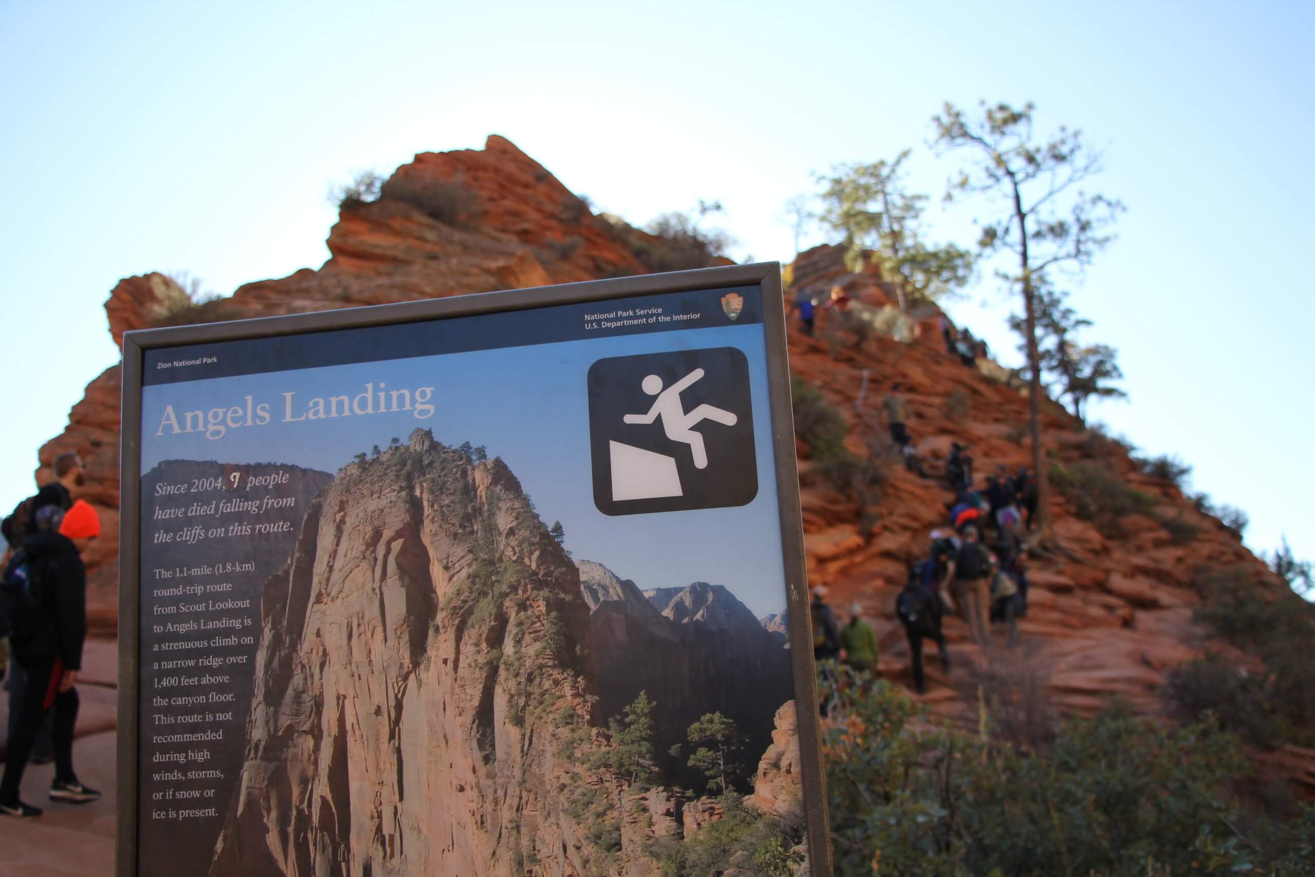
Angel’s Landing is a formidable rocky outcrop. The huge orange cliffs rise some 100 meters into the air meaning that one wrong step could leave you tumbling to your death! While there have been a few deaths over the years, each year thousands attempt this famous US hike and live to tell the tale!
Every year over 3 million people visit Zion national park making it one of the most popular national parks in the USA. Many of these visitors will see Angel’s Landing and quite a few will attempt this memorable hike. In order to hike Angel’s Landing, it is recommended to start early. Park up at the car park and hop on the shuttle bus. Jump off at the Grotto stop which is just a stone’s throw from the Angel’s Landing trail head. There is a rest room here before you head upwards!
Cross the Virgin River and just follow the crowds up to Scout’s Landing. Angel’s Landing is an out and back trail so you will be coming back down this way too. The route upwards will take you into Refrigerator canyon and up the dreaded Walter’s Wriggles before reaching the point of no return. At Scout’s Landing you can decide whether or not you want to go onto the ridge of Angel’s Landing. From here you follow an arete, a knife-edged ridge with the help of some mental chains. Be aware that it can get very busy so if you don’t like crowds this may not be the hike for you. Also, there are pretty steep drops so make sure you have a good head for heights. On the ridge, the real fun begins! There are scrambling obstacles and epic views to be found!
Once you reach Angel’s Landing view point, admire the view then be careful on your way back to Scout’s landing.
The whole trail will take anywhere from 3 – 6 hours to complete. It is about a 5.5-mile hike and is certainly one of the most exciting hikes in the US! If you still aren’t sure whether the Angel’s Landing hike is for you, check out this list of 8 reasons why you should not hike Angel’s Landing.
Blue Basin Overlook Trail – Oregon
By: Jacoba at Op reis met Co
Have you ever heard about John Day Fossil Beds National Monument? It’s a gorgeous park that’s divided in three separate units, and the Painted Hills Unit is the most well-known. However, I found the Sheep Rock Unit even more beautiful and it is home to one of the most beautiful short hikes in Oregon.
It’s called the Blue Basin Overlook Trail, a loop trail which is only 5 kilometers (3.1 miles) long and the landscapes changes around every corner. To get to the trailhead, you’ll have to get to the Blue Basin Parking Area, which is located on the right side on the John Day Highway, if you come from the visitor center.
From there, you can just follow the signs. There are hardly any side trails, so you won’t get lost. The trail starts flat, but at some point, you’ll start climbing, and see the landscape change. From grassy meadows, you suddenly see red-painted hills and rock formations that seem to be green and blue. About 1 mile in, you’ll see the last tree on the trail, after this there won’t be any shadow at all. So bring enough water!
At some point, you’ll reach the Blue Basin Overlook and you’ll be overwhelmed with the view. It’s something you probably have never seen before, there’s actually some sort of basin in the mountain that has blue-green cliffs!
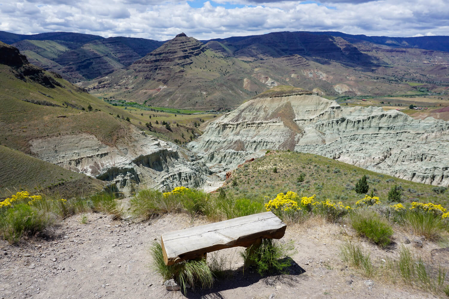
Going back down is another highlight, the trail is winding over the hills and the views of the valley and the John Day River are absolutely gorgeous.
When you get back down, you can opt to go to the right and extend your hike a little by hiking the short Islands in Time Trail, which will take you inside the Blue Basin. If you go to the left, you’ll be back at the parking lot in no time.
It’ll take about 1 to 1.5 hours to hike Blue Basin Overlook Trail and you probably won’t see any other hikers, since not many tourists seem to find the John Day Fossil Beds National Monument. But I’m pretty sure that’ll change soon, because it’s one of the most beautiful places in Oregon!
Wire Pass
By: Kristin from That Traveling Family
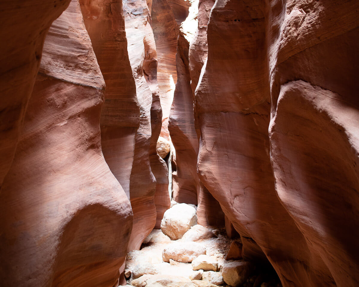
The US Southwest is full of amazing landscapes and incredible hikes, but one of the best hidden gems is the Wire Pass Slot Canyon hike. Located between Page, AZ, home to Lake Powell, and Kanab, Utah, Wire Pass trail is an easy 3.4 mile out and back hike to the confluence with Buckskin Gulch, or extend the hike as long as you wish through Buckskin Gulch.
Many tourists flock to the gorgeous Navajo sandstone slot canyons near Page, like Antelope Canyon, but Wire Pass remains relatively unnoticed- yet. And, unlike many of the other slot canyons in the area, there is no group tour required to enter.
To get to Wire Pass, you’ll probably want an SUV as the dirt road to the trailhead, although in good condition, can be a bit rough in patches and sections flood easily. No advance permits are required, but you will need cash to pay for the day use fee.
Once on the trail, the hike follows a wash most of the way to the slot entrance, which is about a mile from the trailhead. Once you enter the slot portion, you will be rewarded with tall and smooth gorgeous red sandstone walls. There is an 8-foot rock scramble shortly after entering the slot so come prepared. There is an old ladder in place to climb down, but it is not for someone with mobility issues. However, the lower portion of the slot canyon is even taller and tighter, so it’s worth the climb.
Shortly after exiting the Wire Pass slot, you’ll find ancient petroglyphs carved into the sandstone walls. At this point, turn back, or continue on to keep exploring Buckskin Gulch.
Keep in mind that slot canyons are incredibly dangerous with even the slightest amount of rain. Make sure to check the forecast before beginning the hike, and if you notice any signs of a storm while hiking, turn back immediately. Slot canyons can fill with rainwater within a matter of minutes, so this is not something to take lightly. But, with proper planning, this incredible hike deserves a spot at the top of any outdoor lover’s bucketlist.
Reef Bay Trail
By: Kristin at Snorkel and Hike
Located in the U.S. Virgin Islands National Park on St. John, the Reef Bay Trail is a strenuous 6 mile out and back hike. With the tropical forest, ancient petroglyphs, a waterfall, and ruins of a sugar mill there’s plenty to see on this day hike. Luckily, for those looking for something a bit easier, there’s the possibility of a 3-mile “out only” hike guided by a park ranger with a boat pick up at the turn-around point on the beach.
Parking is difficult for this hike, as there are only a few small spaces along the mountain road to pull off near the trailhead. So, if you plan to drive to the Reef Bay Trail, arrive no later than 10 a.m. to hopefully get one of the available spaces.
Shortly after beginning the hike, you will pass the lookout point with a view down the mountain all the way to the ocean turn-around point that gives an idea of what’s in store. If hiking on your own as an out and back hike, the first 3 miles will be descending the mountain with the return entirely uphill. If you’re more interested in the shorter guided hike, contact the Virgin Islands National Park for the dates and times of the guided tours.
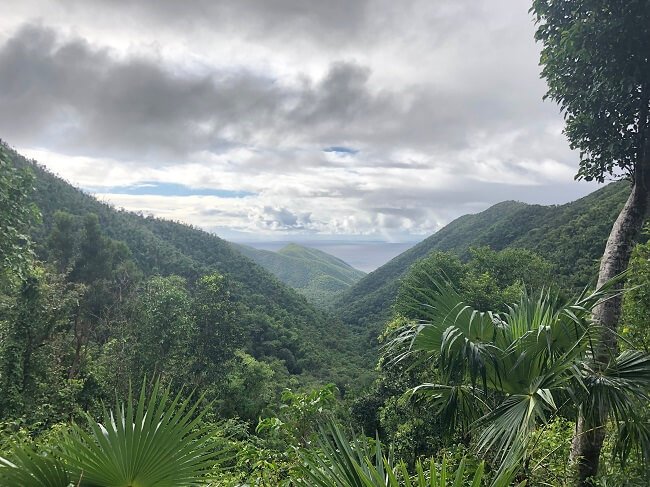
The lush and often humid tropical forest provides plenty of beautiful scenery, including some of the largest trees on the island. About a half mile in from the turn-around point, a fork in the path will lead to a waterfall with ancient Taino petroglyphs carved into the rocks.
After passing the waterfall trail, there is an abandoned sugar mill to explore near the ocean. If you brought swimming clothes, reward yourself with a dip in the clear blue water of the bay before beginning the 3-mile ascent back up the mountain.
Although a moderately difficult hike, it is one of the most rewarding and interesting in the Caribbean. No matter which hiking option you choose, the Reef Bay Trail is a can’t miss for any hiker visiting the Virgin Islands.
Sam’s Point
By: Lucile at LucileHR.com
The mountainous region of Catskills offers plenty of hiking opportunities. One of the best hikes you can complete in a day is at Sam’s Point Preserve. If you want to explore majestic ice caves and just marvel at the spectacular view of a cascading waterfall, get ready for a whole-day experience that will surely be memorable.
One of the best things about Sam’s Point is that you get to have plenty of nature scenes- and with that, I’d easily recommend it to anyone planning to get out of NYC to refresh their minds.
From New York City, the best way to get to this trail is by train, which will usually take you two hours and a half. If you’d rather take the bus, it’ll take longer – about 20 minutes more. You can complete the out-and-back trail in approximately five hours, clocking in a total of 7.4 miles.
Below is a list of the natural splendor you get to experience at Sam’s Point:
- Appreciation of the beauty of nature from Sam’s Point, which you can reach only less than a mile from the parking lot. Here, you can have breathtaking views of the Shawangunk Ridge and Wallkill Valley.
- Exploration of the mysterious ice caves – don’t forget to bring gear to warm you up. It gets pretty chilly and dark in there
- Walk through the remarkable dwarf pitch pine forest
- Perch atop the spectacular 187-foot high VerkeerderKill Falls, definitely an experience and scene one should not miss.
Personally, I would like to highlight the ice caves as a hiking experience like no other. Don’t ever leave Sam’s Point without ever checking out the ice caves. Need to hike within a cave without a guide? The ice caves can give you that opportunity.
The whole place is warmly lit for that added ambiance in this tranquil place. You can easily walk the carved stairs, wooden bridges, and climb ladders. All that would take about an hour.
All in all, Sam’s Point is not a difficult hike to take. It is perfect for hikers who want a more awesome experience out of New York City destinations. It is also an excellent way to get fit while traveling to New York. If you want a rather different experience that will make one of the best memories you have, Sam’s Point is the trail for you.
Concluding Thoughts
There are so many amazing hikes in this country it would be impossible to list them all. I hope this little taste of some of the best day hikes in the US inspires you to pull out your hiking pack and hit the trail.
From the east coast to the west and everywhere in between, there is something for everyone.